MIST
Magnetosphere, Ionosphere and Solar-Terrestrial
Tomographic imaging of travelling ionospheric disturbances
By Karl Bolmgren (University of Bath)
The ionosphere, the electrically charged upper atmosphere, has important effects on technologies like radio communication and satellite-based positioning. For high-accuracy positioning using Global Navigational Satellite Systems (GNSS), such as the Global Positioning System (GPS), ionospheric models are often used to estimate the ionospheric effect on satellite to ground communication. This effect is determined by the ionospheric electron content, and sudden changes or disturbances in the electron content can be challenging to include in such models.
A common type of disturbance called Travelling Ionospheric Disturbances (TIDs) are caused by gravity waves in the ionosphere, which are present all over the globe. They can be observed as wave-like fluctuations in Total Electron Content (TEC) and come in widely different spatial and temporal scales. The largest TIDs are generally caused by geomagnetic storm activity, while the more common, smaller TIDs can be caused by activity in the neutral atmosphere, like thunderstorms, perturbations from earthquakes or tsunamis, and the sudden temperature gradients associated with the solar terminator. In order to improve existing models and learn more about TIDs, we need reliable methods to study them.

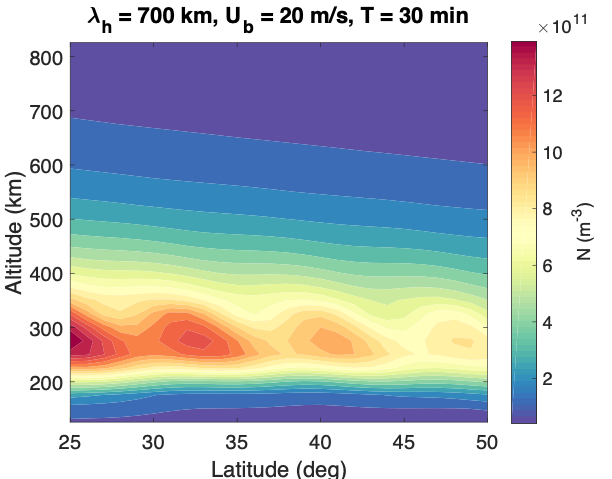
Figure: Cross-section electron density of a modelled TID used to evaluate the tomographic images. For this particular simulation, a horizontal wavelength of 700 km, an initial perturbation speed of 20 m/s, and a period of 30 min was used.
Computerised ionospheric tomography is a powerful tool to image the ionosphere. Tomography is a technique used to reconstruct the 3D structure of an object from integrated measurements and is commonly used in e.g. medical imaging. In ionospheric tomography, the 3D ionospheric electron density is reconstructed from integrated measurements of TEC. We have used simulated TIDs to test how well ionospheric tomography can be used to image different scales of TIDs, and an example of a simulated TID is shown in the figure. We showed that incorporating geostationary satellites can significantly improve the imaging of TIDs. The imaging technique has significant implications for how we observe and investigate ionospheric features, such as TIDs, and presents a method to incorporate these phenomena into existing ionospheric delay correction techniques for applications like GNSS.
For more in details, please see:
Bolmgren, K., Mitchell, C., Bruno, J., & Bust, G. (2020). Tomographic imaging of traveling ionospheric disturbances using GNSS and geostationary satellite observations. Journal of Geophysical Research: Space Physics, 125, e2019JA027551. https://doi.org/10.1029/2019JA027551